Tour 5 2015 Tour 6 2015 Tour 7 2016 Tour 8 2016
START OF TOUR 3 2014-15
October 2014 - February 2015 ....124 days
Wet season Part 1 (Oct-Nov) : 🌞38°C / 🌒32°C.
Although days can start with clear skies and good visibility, heavy rain is
always nearby with huge thunderstorms and high winds appearing by 1100L.
Wet season break (Dec) : 🌞44°C / 🌒37°C, temps hitting 🌞50°C in high humidity.
Mostly rain starts in the afternoon and lasts until early the next day. Sunrise with low cloud
in the highlands clearing by 0900L but the dangerous build-up still starts by 1100L.
Wet season Part 2 (Jan-Apr) : 🌞42°C / 🌒36°C.
The wettest months with non-stop rain for days.
When it does stop high humidity quickly turns into massive thunderstorms and often only
one or two flights can be completed each day before the winds close the mountain airstrips.
Koteka - confirming beyond doubt that I am back in Papua Wikipedia Although called back from leave 10 days early in the wake of the Chief Pilot Mark's departure,
our whole Nabire team is looking forward to restoring functionality to our operation
and finally being able to do our jobs
Engineers Meli and Marsel and I were grateful to receive a visit from Asian One Air owner Silvi and her Mother to provide support
.JPG) |
Nabire, Papua - the jungle wall
Alive with every imaginable creature and impenetrable without a machete |
.JPG) |
Nabire, Papua - the jungle wall
|
.JPG)
|
Papua highlands - the raging Derewo river, jungle and landslides ( old and new )
|
|
| Sugapa - native dancers welcoming a visiting dignitary at the airstrip |
|
| Sugapa native dancers lining up to lead the VIP procession into town |
|
Our Laundry Service shack.....
|
Our favourite Laundress.....
|
| Nabire's Supermarket and Department Store....the Lucky |
.JPG) |
| Rushhour at the fuel pumps.... |
.JPG) |
Formula 1 Nabire - one of the many vans for hire which cruise the streets and will bring you wherever you want for a small fee - as long as you do not mind sharing with up to 30 Papuas.
I have also seen the names FIFA World Cup, UEFA Football-Wagon as well as Black Warrior, Razor, Ghetto Blaster and, most appropriately, Death on Wheels
|
.JPG) |
| Nabire - the bank |
.JPG) |
| Nabire - CFC Crispy Fried Chicken |
.JPG) |
| Nabire Airport - Old and New Control Towers |
.jpg) |
Another trip to the Sinak Valley.
The 7310 ft 2230 m elevation airstrip is very rough with only 450 m of the 650 m useable.
A new runway is being built (crossing at a right angle) but will take time.
There is frequent independence militant and bandit activity in the valley
and the Bukit Kandoe ( hill on the right ) is a stronghold.
During times of high tension (political, inter-tribal or opium harvest) aircraft passing close to Bukit Kandoe are shot at |
High tension in Sinak requires a curved approach and a steep descent to avoid the Bukit Kandoe hill, from where militants/bandits will shoot at you even though you are bringing in food, supplies and medicine for their families. The steep descent needs to be turned into a climb to touch down with a rate-of-climb on the 10% slope of the 7310 ft 2230 m elevation airstrip of which only 450 m is actually useable
Scenic Sinak - not a nice neighbourhood so a walk down the runway requires an escort
|
Scenic Sinak - boulders on the runway and the 12330 ft 3760 m peak
of Gunung Gogobak in the background GoogleMaps .
|
.JPG) |
Mahavira Hotel staff at their best changing a lightbulb
....if not one way, then another
SusiAir PK-VVZ joined us on the apron in Bilogai
There are some crazy winds around the south ridge this morning
|
.JPG) |
Rhino beetle assisting with the loadsheet
|
|
Sinak airstrip perimeter
The flag establishes a political presence and also works as a windsock
|
|
Outside the perimeter of Sinak airstrip
...not the safest neighbourhood so an escort is mandatory |
|
| Starting the day's flying at 0550 local time and already a monster CB (Cumulonimbus) is heading our way Wikipedia |
|
| Indonesian flavour combos never cease to amaze : green beans baked into a sweet bun |
|
| Sugapa MEDEVAC patient being handed over to ambulance crews in Nabire |
|
Me in my new Batik formal shirt with our Engineers Marsel and Meli
for a crew night out at the Moon Beach resort
|
Batik and Sunset
|
Crew night out at the Moon Beach Resort north of Nabire
( also called the Pantai Mona Lisa ) GoogleMaps |
|
Moon Beach Resort pier
Rhino beetle leaving the pier party early
.jpg) | Entering the Freeway - winds curving around the northern boundary range
| | Early morning Freeway - cloudpour |
|
|
|
Ilaga - unloading a personal record-to-date 277 kg pig.
Actually, I was only watching ...from a distance.
It was not unusual for a crate to be dropped and the angry occupant getting loose |
|
Taking advantage of an unusually clear and calm day to enjoy the north plateau bordering the Sudirman Range as it rises to become the Puncak Jaya, Indonesia highest mountain.
Our altimeter indicates 12500 ft 3800 m above sea level, but we are actually flying 1500 ft 460 m above the ground
|
|
| Now flying 1000ft 300 m above the ground with the altimeter still indicating 12500 ft 3800 m above sea level, we pass over the plateau north of the Sudirman Range and the Puncak Jaya GoogleMaps |
|
Seen from the plateau north of the Sudirman Range, the 15500 ft 4750 m peaks of the North Wall hide the Puncak Jaya, Indonesia's highest mountain at 16024 ft 4885 m above sea level
| Passing Mil-8 ER-MGX in the Freeway
|
Passing Mil-8 ER-MGX on a cloud day
Boat trip with the crew of Mil-8 ER-MGX to Nuburi island coral reef
GoogleMaps |
Pulau Nuburi coral reef
|
Pulau Nuburi coral reef
Nuburi curiosity |
|
| Pulau Nuburi coral reef - predator starfish inching in for the kill |
|
| Chief of Security for Highland Airports - employed to keep people off the runways |
A few days later the same pig caused an emergency stop after landing - by European standards this sounds dramatic but in Papua it is an almost daily occurrence
|
A gift from a colleague returning from holiday : Javanese 'Blangkon' headdress Wikipedia
which we honoured with a traditional dance
|
|
Unloading emergency building supplies in Sugapa
....urgently required after the recent tribal unrest
|

|
Not my best pic, but not bad for through the window from 5 miles away :
AMA Pilatus Porter passing low over the jungle below us in the Freeway |
|
Eastbound at 11500 ft 3500 m through the Beoga Pass enroute to Ilaga.
The Pass directly below us lies at 9300 ft 2330 m and the ridge on the wingtip
reaches 13200 ft 4020 m and extends for 30 NM |
|
Unloading a 180 kg pig at Ilaga WABL
( not even close to my personal record pig passenger ) |
|
The spot on the Ilaga apron where a woman walked into a TwinOtter prop two weeks previously
...see Post 30Dec14 |
|
| To prevent further tragedies, a crowd control fence has been installed |
|
Rush hour at Ilaga
AMA PAC750 PK-RCE on the move in Ilaga
Worth having the sound ON
When the sound of the aircraft fades you can hear the voices of all the people milling about the apron
|
|
| AMA PAC750 PK-RCE rolling on Runway 07 |
|
PAC750 departing Ilaga - runway length 603 m and threshold elevation 7975 ft 2430 m.
The peak is the Gunung Kelabo 13350 ft 4070 m beyond which lies the Sinak valley
GoogleMaps
Ilaga Rush hour from inside - wait till the end |
|
Church of the Guiding Light in Kali Merah Wadio village near home-base Nabire. The size, position and angle to the sun coincide to make it shine and visible from a great distance. Even on bad weather days it is often visible thru a hole in the clouds….and brings us home Guiding Light | On a day off we decided to find this Guiding Light
but a wrong turn found us off the track and stuck for a while
Our 'Church of the Guiding Light'
Actually called 'Eklesia' in the Kali Merah area of Wadio village.
'Kali Merah' translates to Red River and refers to the nearby Kali Bumi
GoogleMaps
|
|
|
| The current church/village hall in Kali Merah with a curious congregation. The villagers have been solely funding the building of the new church hall themselves since 2009 |
|
| Work in progress on the new church/village hall of Kali Merah |
|
| New church/village hall under construction in Kali Merah |
|
SusiAir Pilatus PC6 Porter on the ground at Hitadipa
GoogleMaps |
|
Nutritious Durian fruit - enthusiastically welcomed when in season for its flavour
and mild alcoholic/hallucinogenic qualities.
Papuas will leave the Durian to ferment in the sun, often with tragic results |
|
Bilogai Tutup = Sugapa's airstrip is closed due to rioting
(difficult to see, but there is a lot of debris on the runway) |
|
Unusual sight of gold mine helicopters PK-USA and PK-USS both
under cover at the fire station for maintenance |
 | A final Christmas load in a mid-morning temperature of 42°C and 97% humidity
....a reminder that we are only 200 NM 370 km south of the equator
on the opposite side of the world from Europe
|
|
| We will continue to go into rough airstrips in the new year - gravel deflectors |
'nuff zed
|
| New Year's Eve 2014 : fellow pilots Swiss-Serge and French-Claude as we crossed the runway to the Company fireworks party in a humid 30°C
|
|
Dutch-Remco and French-Claude on Nabire's runway
heading for the Company New Year's party |
|
| Our Company fireworks street party |
|
| GloStix from Glasgow are always popular |
|
| Wheelbarrow BBQ with Rapster Chef and his fish |
|
| Enjoying the fireworks while sheltering from the rain - which reduced the fire hazard to the town. The lens is not foggy - that's smoke. |
|
| Moisture steaming off the highland jungle at 7500 ft 2290 m elevation |
|
| On the apron at Nabire WABI waiting for the rains to clear |
|
The yellow dot is helicopter PK-USS heading for the Bayabiru gold mine
|
GoPro looking down - Nabire town Upload 21Dec14
|
Ruslan's first marshalling - close enough for a lollipop prize
...see Post Tue30Dec14 |
Marshalled into a tight parking spot ....with 1 x marshaller and 3 x assists this is going to cost my whole box of lollipops
|
GoPro looking down - Unipo gold mine along the Sirowo river
GoogleMaps |
On a return from the mountains
we carried a large, very smelly and diseased looking dog back to Nabire
along with its owner and escort ….I assume for a visit to the vet. The poor
thing sat quietly looking sad the whole trip. |
|
Nabire - our hotel 'Mahavira 2' is the L shaped yellow building.
'Mahavira 1' is the L shaped tin roof in front. |
|
AMA Pilatus PC6 Porter on the ground at Bilai
GoogleMaps |
|
Pogapa - adorned with the wrecks of two Caravans
GoogleMaps |
 |
| CB (Cumulonimbus) with cap |
|
Landslide - scale not obvious but that is a drop of at least 2500 ft 760 m
|
|
| Looking straight down - Papua jungle |
GoPro looking down - Bumi river gold mines
|
| Looking in |
|
| GoPro looking down - Papua jungle |
|
GoPro attached to the tailcone, looking down - posing with Ramli, our man in Bilogai
|
|
Freeway waterfall - seen from 3 NM and falling at least 500 ft
Freeway waterfall seen from 2 NM distance - a huge volume of water dropping at least 800 ft
|
|
| Loading construction materials |
 |
Early morning insect on the apron
|
|
| First thing in the morning the aircraft is always covered with insects |
 |
| Early morning insect |
|
| Early morning insect - this one got under my seat, was released and then nearly got eaten by a passing bird |
|
Noisily unloading pipes at Sugapa
|
|
| A special lunch prepared by Engineer Meli's Mum |
|
Our aircraft seen in a cloudy Freeway at 10500 ft 3200 m.
It may sound high but we are only 5000 ft 1520 m above the valley floor
and 1500 ft 460 m below the hidden mountain a few miles to our right |
 |
Checking the load
Old landslide and the Derewo river |
|
To give a sense of scale - that dot is a Pilatus Porter going towards Bugalaga
( the lighter strip on the ridge on the right YouTube ) |
 |
Our next load of 700 live chickens keeping cool in the shade
....and nobody noticed the ants in the grass |
 |
Loading 700 chickens and, unwittingly, 1000s of ants - see post dated Tue30Dec14
.jpg)
The chickens' owner ....and an escapee who stayed in that spot and clucked happily and noisily the whole flight.
It was common for the owner of a cargo to join the flight
Just a few of the 1000s of ants brought on board with the chickens
....see post dated Tue30Dec14
|
|
| Passing another aircraft in the Freeway - it gives a sense of the unbelievable size of the mountains |
|
The airport staff were otherwise engaged
....so we used our propwash to remove this FOD from the centre of the runway
Wikipedia |
|
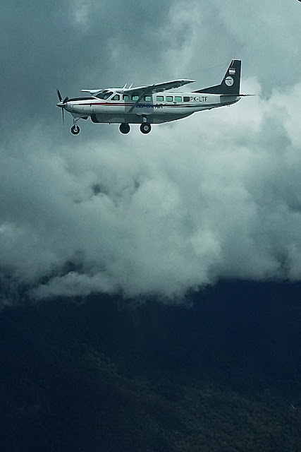
Finally some nice pics in good weather of our aircraft in flight :
Asian One Air C208B PK-LTF in the Papua Freeway
as seen from a passing SusiAir C208 |
|
Asian One Air C208B PK-LTF in the Freeway
at 10,500 ft 3200 m |
|
A week later an Enggang Air Caravan got this nice photo of us
in the Freeway at 8500 ft 2600 m |
|
Missionary John Cutts from Pogapa www.villageheartbeat.org who has served Papua for 60 years and featured on the TV Series "Worst Place to be a Pilot"
|
|
Papua 2015 - bridge still under construction
2025 - recently built bridge but a disturbing deforestation GoogleMaps |
|
Our Engineer Marsel in a rice paddy getting us a sample
|
|
| What rice really looks like - the black and white varieties |
|
Rushhour at Bandar Udara Nabire.
It is not unusual for several aircraft to enter the runway and backtrack at the same time,
the last in line taking off first ....with the ever-present rotaries doing their own thing in the opposite direction just beside us
|
|
| The jungle just outside Nabire - some of these trees are 150 ft 45 m tall |
|
MAF Grand Caravan PK-MAE in the Freeway
| |
Missionary Aviation Fellowship MAF Grand Caravan in the Freeway |
|
| The sea breeze sending moisture up over the jungle plateau east of Nabire |
|
Going east, as the terrain rises again, cloud pouring at the entrance to the Freeway
Departing Nabire on a rare Saturday with no flying I shared a boat trip into Cenderawasi Bay with friends from the MAF GoogleMaps
Escorted by a pod of dolphins enroute to see the Whale Sharks
Cenderawasi Dolphins
No problem - Don't worry - Be Happy |
|
A welcoming 'bagan' fishing platform under which two Whale sharks were feeding
(although the big smiles may also have been in anticipation of the generous 'compensation' we paid for 'disrupting' their day's piscatorial efforts)
In the water for the first time with Whale sharks |
|
Whale shark wikipedia
Cenderawasi Whale Sharks
|
|
Curious Whale shark gliding in from under the bagan to have a close look at me.
This is the 'small' one of 4.5 meters so still a juvenile |
| 'Small' Whale shark - no enlargement...they come that close.
The juvenile took his time going past - almost drifting rather than swimming |
|
A few minutes later the 'Big' one came from behind passing under our boat and lightly brushed past - which still tumbled me over her back.
Perhaps a polite check on what the juvenile was playing with
|
The spots and stripes are unique to each Whale shark
|
Curious, gentle Whale shark
This was the 'big' one at 6+ meters
|
Cenderawasi Bay Whale shark
|
Around midday, as the surface water warmed, they just glided away into the depths
Whale shark away into the depths
Approaching Pulau Nuburi in Cenderawasi Bay GoogleMaps |
| Cenderawasi - Approaching Pulau Nuburi |
|
Pulau Nuburi
|
Pulau Pepaya seen from Nuburi
Further away than it seems and said to be a mangrove with no beach |
Nuburi - a 150 metre circle of paradise
Note the conifers - apparently a Dutch colonist planted some on the mainland
100+ years ago and some seeds ended up here
|
| |
Pulau Nuburi reef - just off the beach is an area of sea grass and a few corals
Pulau Nuburi coral reef
Pulau Nuburi coral reef
Nuburi corals and reef inhabitants
|
|
| Pulau Nuburi - fish congregating in the surf |
Nuburi - fish and feet
Departing Pulau Nuburi |
 |
Was it something I said ?
|
| Long line sling load being lifted to a remote site |
|
| FOD on the strip at Bilogai. The fate of the owner remains unknown. |
|
A beautiful bug who got up my trouser leg.
Normally this causes a girlie scream, some leaping and leg shaking and a murder
....but the offender was too stunning for that. |
|
The Freeway eastbound in the early morning
The peaks in the distance reach 13200 ft 4020 m |
|
| Hand luggage - Papua style |
|
Short finals for RWY09 at Bilogai - 600 m long, 6960 ft 2120 m elevation
and an early morning temperature of 25°C
|
|
| Touchdown on the gravel and applying Reverse Thrust as soon as we reach the asphalt on landing at Bilogai |
|
| Snack vendor outside our cargo office |
|
| A fuzzy pic of cloud pouring over the 12200 ft 3720 m Weyland massif 30 NM away GoogleMaps |
|
Jail Break - fugitives recaptured. The one on the left made it all the way across the apron.
For the sake of clarity ...we are talking about the roosters |
|
Catching up with AMA's Pilatus Porter PK-RCY in the Freeway
|
|
Associated Mission Aviation Pilatus PC6 Porter
( a nice pic and I am proud that it is still in use on the AMA website in 2025 ) |
|
| Crime prevention - Papua style |
|
On an unusually clear day looking South from overhead Bilai,
situated on the valley floor at 5800 ft 1770 m above sea level. GoogleMaps
The 1st ridge is 'only' 8100 ft 2470 m and defines the southern edge of the Freeway.
The high point on the 2nd ridge (possibly named Kendatapa) sports 10000 ft 3050 m.
The jagged ridge on the horizon, 16 NM 30 km away
is part of the Sudirman Range at 13400 ft 4090 m. |
|
| Traditional gold mining at Baya Biru along the Derewo River |
|
Marsel and Rango ..... Ground Team ride-a-longs are always fun
Last run of the day
....one of the mining helicopters departing in a rush to get there and back before sunset |
A nice TC (Towering Cumulus) with ambitions to grow into a CB (Cumulonimbus)
welcomes us into the Freeway
|
Turning towards the 7400' KeyPoint (Blue-Red-Blue buildings) for Finals at Bilogai
An explanation of Key Points to follow during 2026 - I hope
|
|
Unloading 1500 kg of rebar
|
Sugapa town (Bilogai)
|
| Freeway - skirting clouds |
|
Leaving the Freeway Westbound with the coast on the horizon
|
|
Staring descent into Nabire - where the Utuwa and Siriwo Rivers meet GoogleMaps
|
Same spot - different view
|
East of Nabire - gold mining along the Kali Bumi
The Kali Siriwo as it snakes northwards toward the sea
GoogleMaps
|
|
Jungle plateau East of Nabire WABI
|
Approaching Nabire 4 minutes from touchdown.
The coast and airport are immediately behind the 1700 ft 520 m ridge ahead
|
| Joining Finals 34 at Nabire |
|
Bandar Udara Nabire Douw Aturure
( the tribal name of a popular local Regent )
Boat trip to the islands North-west of Nabire.
Unspoiled and mostly uninhabited in 2014 ...not so in 2025.
As is common in Papua most of the islands' names have changed too
Boat trip to the islands North-west of Nabire
|
| Uninhabited islands 1 hour boat ride NW of Nabire |
.jpg) |
Approaching Pulau Babi - uninhabited, but note the antenna
(in 2025 it also seems to be known as Meips Island) GoogleMaps |
.jpg)
Pulau Babi
Pulau Babi
|
| Pulau Babi with Pulau Ahe in the background |
|
Pulau Ahe in 2014 still unspoiled and uninhabited.
The jungle reclaiming all that remains of a hotel once built on the island
( the owner did not get along with the local Chief and there was an accident ).
The 2025 remnants of the pier are pinned on GoogleMaps.
Ahe now seems to be called Kopataor and the shape of the reef and even the beach are barely recognizable
|
|
Pulau Ahe - WW2 aircraft engine.
The rest of the wreckage lies somewhere on the reef, said to be within reach during low tide.
Unfortunately the tide started coming in and our search ran out of time.
We returned to Ahe during Tour 5 and found a wing and part of the fuselage |
.jpg) |
| Pulau Ahe coral reef |
Pulau Ahe coral reef
Nabire seen from the northNote the small coral reef in the centre of the photo.
During Tour 5 we saved the GPS position and took a boat trip there one afternoon
|
Our Engineer Meli cleaning up Nabire's Apron
|
|
Our first passenger of the day - we rolled 10 m before he let go
|
|
| Heading home ....transiting through picturesque Pattimura Airport on Ambon GoogleMaps |
-----------------------------------------------------------------------------------------
Although it look's like a big happy adventure there are some problems too.
The joys of food poisoning and tropical diseases, corruption and a national culture
often not suited to aviation means Papua is a challenging place to fly
....and sometimes the luck runs out.
Each tour page ends with some of the accidents which happened during that time.
A yellow bloc means I knew the people involved. Black means it was fatal.
|
-----------------------------------------------------------------------------------------
END OF TOUR 3 |

.JPG)
.jpg)
.jpg)
.jpg)
.JPG)
.JPG)
.JPG)
.JPG)
.JPG)
.JPG)
.JPG)
.JPG)
.JPG)
.JPG)
.JPG)
.JPG)
.JPG)
.JPG)
.JPG)
.JPG)
.JPG)
.JPG)
.JPG)
.JPG)
.JPG)
.JPG)
.JPG)
.JPG)
.JPG)
.JPG)
.JPG)
.JPG)
.JPG)
.JPG)
.JPG)
.JPG)
.JPG)
.JPG)
.jpg)
.JPG)
.JPG)
.JPG)
.JPG)
.jpg)

.JPG)


.jpg)
.jpg)
.jpg)


.JPG)
.JPG)
.jpg)
.JPG)
.JPG)


.JPG)


.jpg)


.jpg)
.jpg)

.jpg)


.JPG)
.jpg)
.JPG)

.jpg)


.jpg)
.jpg)
.jpg)
.jpg)

.jpg)
.jpg)
.jpg)
.JPG)


.jpg)
.jpg)


.jpg)
.jpg)
.jpg)


.JPG)


.jpg)
.jpg)
.jpg)
.jpg)
.jpg)


.jpg)

.jpg)
.jpg)
.jpg)
.jpg)
.jpg)
.jpg)
.jpg)

.JPG)
.JPG)
.jpg)
.jpg)
.jpg)
.jpg)
.jpg)
.JPG)
.jpg)
.jpg)
.jpg)
.jpg)
.JPG)
.jpg)
.JPG)

.jpg)
.jpg)


.jpg)
.jpg)
.jpg)


.jpg)
.jpg)
.jpg)
.jpg)
.jpg)
.JPG)
.JPG)


.JPG)
.JPG)
.jpg)
.jpg)
.jpg)
.JPG)
.JPG)

.jpg)
.jpg)
.jpg)
.jpg)
.jpg)
.jpg)

.jpg)
.jpg)
.jpg)
.jpg)
.jpg)
.jpg)
.jpg)
.jpg)
.jpg)
.jpg)
.jpg)
.jpg)
.jpg)

.JPG)
.jpg)
.jpg)
.jpg)
.jpg)
.jpg)
.jpg)
.jpg)
.jpg)
.jpg)
.jpg)
.jpg)
.jpg)
.jpg)
.jpg)
.jpg)
.jpg)
.jpg)
.jpg)
.jpg)
.jpg)
.jpg)
.jpg)
.jpg)
.jpg)
.jpg)
.jpg)
.jpg)
.jpg)
.jpg)
.jpg)
.jpg)
.JPG)
.JPG)
.jpg)
.jpg)
.jpg)
.jpg)
.jpg)
.jpg)
.JPG)
.jpg)
.JPG)
.jpg)
.jpg)
.jpg)
.jpg)
.JPG)
.jpg)
.jpg)
.jpg)
.jpg)
.jpg)
.jpg)
.jpg)
.JPG)
.JPG)
.JPG)
.JPG)
.JPG)
.JPG)
.JPG)
.jpg)
.jpg)
.JPG)
.JPG)
.jpg)
.jpg)
.jpg)
.jpg)
.jpg)
.jpg)
.jpg)
.jpg)
.JPG)
.jpg)
.jpg)
.jpg)
.jpg)
.jpg)


